Text writer:Junaid & Prosper Reviewer:Prince Host:Prosper Photo:Ahmed Reda Video:Shafee Muhammad
About the Speaker
Professor Fabio Rocca’s research activities have been dedicated to digital signal processing in television bandwidth compression, emission tomography, seismic data processing and Synthetic Aperture Radar. He has been working in Politecnico di Milano since 1967 as Professor specifically teaching Digital Signal Processing. He was the president of the Osservatorio Geofisico Sperimentale in Trieste from 1982-1983. Moreover, he was the coordinator of the first EEC research program in Geosciences and in the coordination committee of the Geoscience II program within the Program JOULE2.
At 19.00, 2ndApril, 2018, Professor Fabio Rocca attended English Geo-science Café no.20 and spoke about Synthetic Aperture Radar System and its applications.At the beginning, host gave a quick prologue of the session and introduced the speakerProf. Fabio Roccain front of the audiences who began his presentation.
Prof. Rocca started his talk with utmost zeal. It was evident from the very beginning that he loves his work and glad to share his work experiences with others.He then outlined 7 parts of his presentation as follows,(1)Why Synthetic Aperture Radar?, (2) Advantages of SAR images over Optical images, (3) Detection of Change in the terrain using SAR satellites, (4)How the use of SAR technology found to be very beneficial based on examples?, (5) Limitations of SAR Interferometry, (6)Applications of InSAR and (7) Advantages of InSAR.
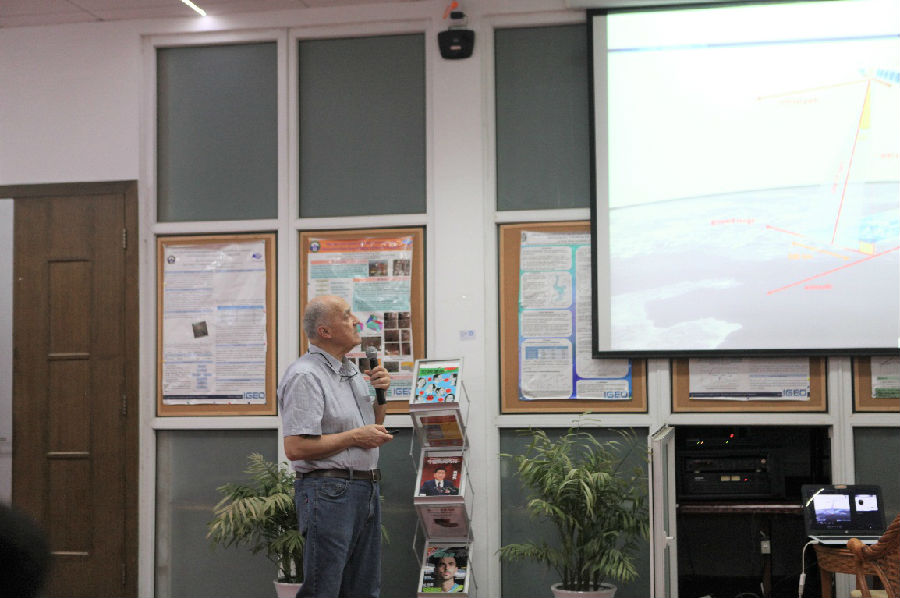
Figure 1 Prof. Fabio Rocca
Prof. Rocca began his presentation by explaining the basic idea of Radar so that those audiences who have no preliminary knowledge about Radar technology can enjoy his lecture. He mentioned, “A radar sends an electromagnetic pulse to a regular target and the time it takes to come back to the Radar Antenna is measured. With time, we can calculate the distance of the target.”
1. Why Synthetic Aperture Radar?
After conveying the basic idea, the Professor then elaborated Synthetic Aperture Radar satellites and its operations. .He said, “A SAR satellite which is around 800 km above the earth’s surface continuously illuminates the terrain as it moves along its orbit”.
Professor then started to reveal the potential application of Synthetic Aperture Rader Systems to the audiences. He said, “SAR system is used to monitor geological changes down to fractions of a meter. This technology also used to monitor the motion of infrastructures, subsidence, slow landslides and the after effects of earthquakes.
2. Why SAR technology is vital for various analyses?
Being personally engaged with the Sentinel-1 project, the professor then explained the need for SAR technology. He said, “Even though the 5 x 20 m resolution of Sentinel-1compared to the half a meter resolution of optical images is quite low, it gives different information about the terrain which makes this technology vital for various analyses”. The professor then demonstrated the capabilities of SAR imagery by showing an example towards the audiences, of an image of Sydney, Australia took with Terra-SAR-X. He added, “The penetration capability of microwave and longer wavelengths from 1 to 20 cm or 30 cm gives SAR technology an edge over optical imagery. The upper limit is projected to reach 70 cm in the come years”.
3. Why do we need SAR images over Optical images?
At a moment, professor through a question towards audiences, “Why do we need such a low-resolution SAR images instead of optical images? A few minutes later he emphasized the advantages of SAR images. He added,
1. No need for external illumination, allowing for true 24-hour monitoring.
2. Able to penetrate atmospheric conditions like clouds, rain, sand and subsurface vegetation.
3. Gives coherent travel measurements down to a fraction of a wavelength 3-20cm. to be used by Digital Elevation Models (DEM) or Deformation maps of terrain to monitor tangible changes.
4. How can we detect changes in the terrain using SAR satellites technologies?
Prof. Rocca then expounded the change detections process in the terrain using this technology. He said, “The detection process involves at least two satellites when they pass over the same location. When each satellite pass, some reference targets are picked and the phase of the wavelength return is recorded in each satellite. Changes in the terrain are then observed by measuring the difference of the phases calculated in each satellite when they pass”. He then added, “The phase shift (Δ?)between the wavelength returns of the two satellite passes is the key to detect change (Δx) in the terrain, whereλ represent the wavelength”.
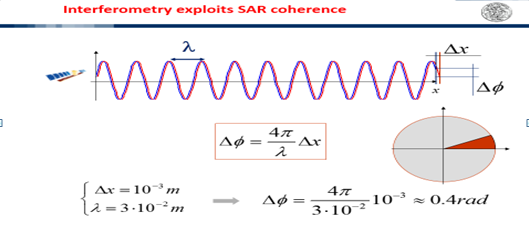
Figure 2 Detection of Change in the terrain
5. How the use of SAR technology found to be very beneficial?
After explaining in and out of SAR technology, the professor then started to share some of his past experiences with the audiences as examples. He explained to the audiences, how the use of SAR technology found to be very beneficial.
5.1 Example-1: BAM Earthquake (26thDecember, 2003)
“In the analysis of BAM earthquake in 2003, the SAR images of before and after the event were analyzed”, he mentioned. In his result, he showed the terrain moved every 2.8 cm which is one half of the wavelength. He also noted that, “the change happens within the Interferometric fringes and the motion was even higher within the town that was destroyed by the earthquake”.
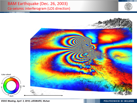
Figure 3 BAM Earthquake effects captured by InSAR
5.2 Example-2: Costa Concordia (13thJanuary, 2012)
Professor Fabio Roccathen gave a second example of a ship named Costa Concordia which was sinking across the Italian Coast in 2012. In which, the concerned were interested to find the shore which was supporting the ship, to be able to raise it out of the ocean. By using Interferometric SAR, they analyzed the fringes to detect the changes in the motion of the terrain which finally enabled them to see the stationary rock which was anchoring the ship. Making it possible to see where to safely raise the ship.

Figure 4 InSAR imagery of Costa Concordia
5.3 Example-3: Identification of permanent scatters
In the third example, the professor explained another application of SAR technologies to detect subsidence objects/features or to detect if the terrain goes up by tectonic folds using pixel by pixel analysis.
6. Limitations of SAR Interferometry
Prof. Rocca grabbed all the audience’s focus when he explained the limitations of SAR technologies, as follows;
6.1 Selection of reliable reference target:He said, “SAR restricts us to pick stable or reliable reference targets. The objects that do not change in time. For instance, rocks, buildings, pipeline or any infrastructure”. Then he explained the difference between “coherent” and “non-coherent” objects in front of the audiences. He added, “Coherent objects are the objects that do not change over time whereas the latter do the otherwise”.
6.2 Atmospheric (parameters) In-homogeneities:Professor said, “In order toextract information about small changes of the terrain, we first need to get rid of the strong changes in the weather such as; effects of clouds”. He further suggested that we can use some Temporal filtering to solve this problem taking into account that the motion on the ground is significantly slower than the motion in the atmosphere.
7. Applications of InSAR
Prof. Rocca enlightened the audience by sharing some applications of InSAR technology, as follows;
7.1TheKatherina Hurricane:
In the beginning he talked about the Katherina Hurricane that occurred in 2006. Professor Rocca said, “by using InSAR, it was found that the levees (which were supposed to block the water from coming into the town) had been sinking by 26.7 mm per year in the course of 13 years”. He added that if it had not been for this sinking levees, the hurricane would be less damaging than it actually was. Eventually, leading tohigher damage and mortality rates once the Hurricane occurred.
7.2 Huangtupo Landslide:
Then he mentioned about theHuangtupo Landslide. He said, “SAR technology can be used to determine the abrupt changes in the velocities along the landslide and this information can be shared with civil engineers to ensure safety”.
7.3 Wide area mapping for Italy:
Professor Rocca mentioned that Italy is prone to landslides due to the subsidence in the Alpines and may be extended to the rest of Europe, China and the rest of the world. All this could be made possible by Sentinel 1 data. The professor also showed an example of the city of Milano where uplift occurred as a result of building destruction. Enhanced oil recovery is another application discussed in the presentation. He added that enhanced oil recovery involves injecting steam into the terrain and when this happened, the terrain rises and this uplift can be measured using InSAR techniques.
The professor also gave an example of the United States where the hydro-fracturing methodology is being used to solve the problem of energy by creating artificial cracks in the rocks that allow gas to penetrate through the rocks. According to the professor, “it is necessary to monitor these areas and find out if any movements are occurring”.
7.4 Insalah Project:
The professor then turned his presentation to the gas reservoir monitoring, which is now compulsory for all gas reservoirs. He mentioned to the audiences that Insalah project in Algeria is being operated by BP, Sanotrac and Statoil. Professor then revealed his findings of Insalah Gas Extraction Project. He said, “The gas extraction process results in the emission of Carbon dioxide. This Carbon dioxide cannot be put in the gas duck. Hence, they extract it using an expensive system (costing about $1 billion). The carbon dioxide is then injected into the sub-surface. The result is a rising terrain”. He also added, InSAR results showed part of the terrain did not rise, which meant that the carbon dioxide was escaping from the subsurface and therefore the process was not effective.
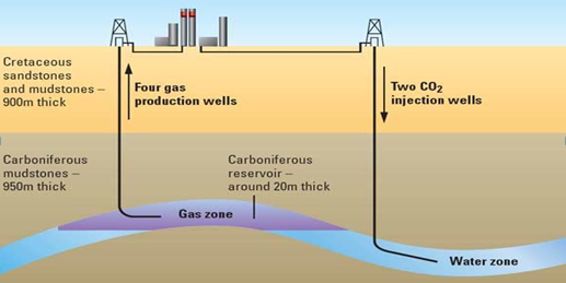
Figure 5 Insalah Project
Beside above examples the professor also mentioned some other examples of InSAR applications as listed below; monitoring of open-pit mining areas, Infrastructure, underground coal mining in Australia, SalthCarvens in Italy, Subway tunnels in London etc.
8. What are the advantages of InSAR?
In the end, the professor Rocca gave the following conclusions about the advantages of InSAR;
· It has high precision (< 5mm on a single measurement and <1mm/yr on mean velocity),
· Wide area analysis (thousands of sq. km),
· Regular updates - with X-band satellites weekly monitoring is becoming feasible with improved benefits,
· 2D surface displacement monitoring, using two or more acquisition geometries, is important to better constrain an inversion,
· Synergy with techniques providing the absolute motion of a few reference points allows to passing from high precision to high accuracy.
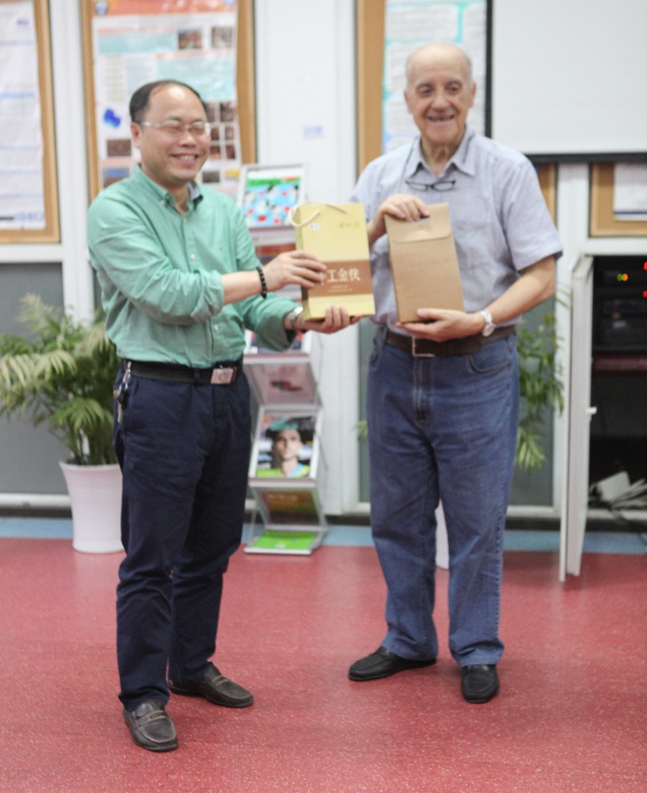
Figure 6 Professor Liao presenting the token of gratitude to Professor Rocca
The EGSC session-20 concluded with a group photo along with presenting the honorable speaker a token of gratitude. This edition of English Geoscience Café was one of the most informative and interactive sessions EGSC has rendered, in which the speaker took the audience on a roller coaster ride from the Middle East to Europe and to Americas with his life experiences.
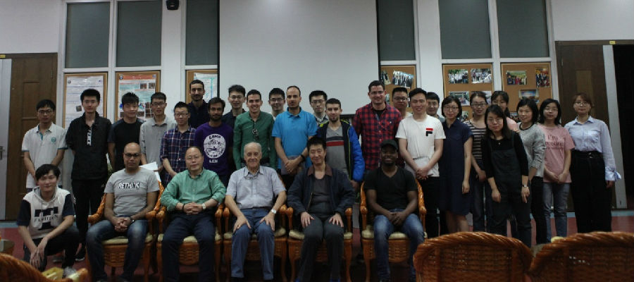
Figure 7 Group photo