Active tectonics of the Corinth Gulf, Greece, the fastest growing rift on planet Earth
Since the beginning of the instrumental seismology in Greece, the most intense seismic activity has been recorded within the Corinth rift and its vicinity. This rift is the most active continental seismic region of the Mediterranean and one of the fastest opening continental rifts in the world. It`s seismic history since the nineteenth century has exhibited more than 10 shallow events with M>6.0
A dense GPS velocity field is used to model the present day deformation by means of a continuous strain and rotation rate field. The geodetic results quantify and refine previous findings as well as yield new insights for the present day deformation pattern in Gulf of Corinth rift. The consistency of the contemporary deformation field with earthquake activity is also evaluated by the calculation of geodetic moment rates and comparison with moment rates determined from earthquake catalogs. In this session, Dr. Arthanassios Ganas presented briefly why Corinth Gulf is known the fastest growing rift on planet earth by the support of his recent research result.
Text: Karim Md Fazlul
Reviewer:李茹(May)
Host: Faisal Shezad
Photo:锁应博(Jack)
Video:徐蕾(Echo)
About the speaker
Dr. Athanassios Ganas completed his PhD in Geological Remote Sensing from the University of Reading, UK. His expertise is Active Tectonics and Geophysical Earth Observation including Fault Interaction, Tectonic Geomorphology and GPS networks. He has published 66 papers in major international journals and has 1019 citations on the Science Citation Index. He serves as member of the Greek National Committee for seismic hazard Assessment and was elected member of the Executive Board of the Geological Society of Greece (Vice-president since 2016). He is a regular member at the Board of Directors of the EPPO (Earthquake Planning and Protection Organization, Greece).
About this English Geo-science Café session
Session: No.18
Venue: LIESMARS 4thfloor leisure hall, Information Sciences Campus of Wuhan University.
Time: 7.00 pm- 9.00pm
Topic: Active tectonics of the Corinth Gulf, Greece, the fastest growing rift on planet Earth
At the beginning, host gave a brief introduction to EGSC. Then he gave a quick prologue of the session and introduced the speaker Dr. Athanassios Ganas.
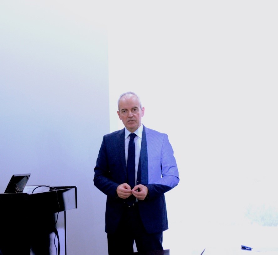
Fig.1Dr. Athanassios Ganas
Dr. Athanassios Ganas started his talk in a lively and pleasant mood. At the beginning of his talk, he asked to turn off the light above the projector window, and shared with audience his experience of 30 years ago, “I remember when I did my master degree in Canada 30 years ago, there was no power point, no computer, people`s were using the slide. So, we had these great geologists, going to the Great Slave Lake in the north-west territory upon the North Pole or North America or Europe, wherever we went, we got really good slide projector and for that, we didn`t need any light, and that presented natural color.”
Then he outlined his presentation: (1) what is fault and why fault model is necessary to study on earthquake? (2) why Corinth Gulf is known as the fastest growing rift on planet earth? (3)What is the mechanism behind it? - by the support of his research result.
1. What is fault? Why fault model is necessary to study on earthquake?
At the beginning, Dr. Ganas offered a definition, “The fault is the utter part of the lithosphere when they grow they generate an earthquake. Actually, the fault is the basic parameter to estimate in a deterministic way the effects of large earthquakes on built environment”.If somebody wants to study on earthquake, they need to have a very clear concept of that area`s existing faults (specifically how many, where, what size and how often).
Dr. Ganas unveiled five main aspects or reasons for the necessity of fault model to study on earthquake. (1) Spatial information: need to know the location, dimensions, geometry and seismic potentiality of each fault, (2) to estimate the slip-rate of faults, (3) to estimate the ground motion using Shake-Map, (4) to know where faults are and predict their damage, and (5) fault can be imported into a digital database for open access by citizens.
Fault model is very important for risk assessment in a hazardous area. What researcher needs is some good field data and precise scientific data to support the model.
2. Why Corinth Gulf is known as the fastest growing rift on planet earth?

Fig.2(1) The two blocks of the finite element model showing the 3D shape of the sub-ducting Nubian slab and the applied displacement vectors, (2) neo-tectonic configuration of central Greece.
Dr. Ganas mentioned that, Hellenic Arc of Greece is the most seismically active part of Europe. He and his research team modeled the deformation along the arc using a finite element model. The model was intended to capture the large-scale 3D structure of Nubian block sub-ducting beneath the Aegean block and its deformation consequences. Then he unveiled the result in front of the audience. He said, “Nubian block is moving 4.9 mm/year in the north-west direction and the Aegean block is moving 33 mm per year at south-west direction”.
Then said, African-Mediterranean plate is moving beneath the Eurasian plate and the Eurasian plate is moving over the African plate, and it generates the fault.
3. What is the mechanism behind it? - by the support of his research result
According to Dr. Ganas, “Along to the boundary of blocks, it generates big earthquake (Up to Magnitude-7). There is also some inter-block deformation. Inter-block deformation is the cause of middle size fault and this fault generate earthquake (Magnitude-6).
“By the help of static and seismic reflection data we already knew what`s happening in the African- Mediterranean plate”, he added.
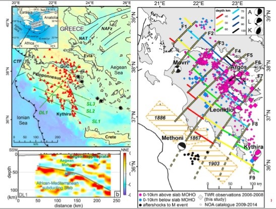
Fig.3The African Mediterranean Plate`s Mechanism
According to his result, the depth of the African-Mediterranean slab varies from 40km to 100 km. His team mainly used big earthquake to map the shape of the African-Mediterranean sub-ducting plate.
He mentioned, “When African plate is beneath Eurasia, it is doesn’t remain as one surface any more, but was broken like slices. So, generally, there is no chance to generate big earthquakes like Japan or Chili. Using seismology to estimate deformation is another tool we have in geology”.
There is a 130 km rift on Gulf of Corinth., where lots of sediment is storage since 5 million ago. From the last 1 million years, the storage rate became faster. So, this 130 km rift is very young and growing fast.
Then he threw a question to the audience, “Why it`s growing so fast? What`s the mechanism? To understand the reason, we collected all of these data from geology, seismology, and geodesy”.
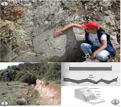
Fig4(1) At the eastern part of the rift there have some young faults and all of these faults are normal in nature. Dr. Ganas assistant shows the direction of slip vector of the fault, (2) this earthquake occurred in 3rd of March, 1981 at the magnitude of 6.3. This is the evidence of deformation on the earth surface, (3) He puts a sketch here just want to show how the things happen.
He said, west side of Corinth rift is gradually extended its sediment. This is the first stage of expansion.

Fig.5Triangular facets, west side of Corinth Rift.
According to Dr. Ganas, “Geomorphology is a very useful tool in fault study. Fossils are the feature of erosion, so we map the fossil because we found that there is erosion between the slope of the fossil and the sea-bed of the faults. This whole area has been beneath water since 1 million years ago”. He added that the west side of Corinth Rift is a very nice area for study active tectonics. He also mentioned that, if you have data, you can try to find out if this relation works in China.
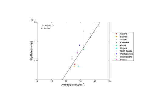
Fig. 6A diagram of Slip rate Vs average facet height for 10 active normal faults. The slip rate is about 0.8 mm/year.
Professor answered, “If we consider all earthquakes as a cluster of single earthquake and take the mean, we can easily say one earthquake happens every 87.5 years in this area. So, statistically, we can predict an earthquake”.
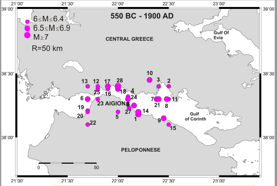
Fig.7Major earthquake data from 550 BC to 1900 AD, in the western part of the rift, Aegion
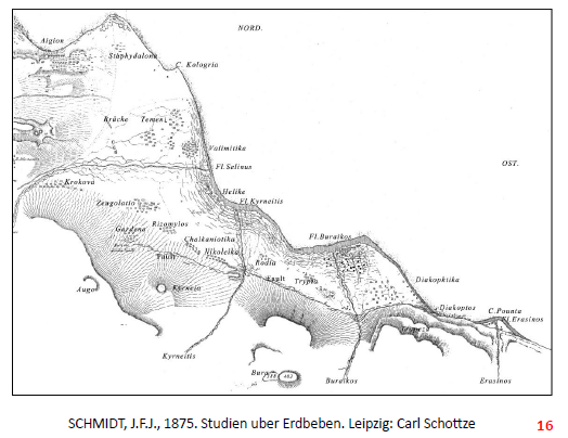
Fig.8There has some controversy about who made the first ever earthquake map! Some said an American geologist made the first ever earthquake map but professor proved that, SCHMIDT, a German, who made the first ever earthquake map in 1861.
According to Dr. Ganas, Moment tensor is a mechanism to find out fault.
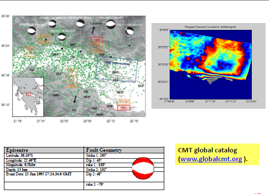
Fig.9The CMT (Global Centroid-Moment-Tensor) project
He mentioned the last major earthquake occurred in this part of the region was in 1995 with magnitude 6.5 Mw.
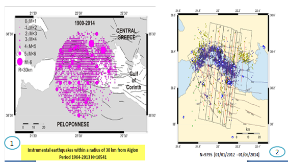
Fig.10(1) 16541 instrumental earthquakes occurred within a radius of 30 km only in Aigion from 1964-2013 periods, (2) from 01-01-2012 to 01-06-2016, 9795 earthquakes took place in this area and we see most of the seismicity formation is offshore.
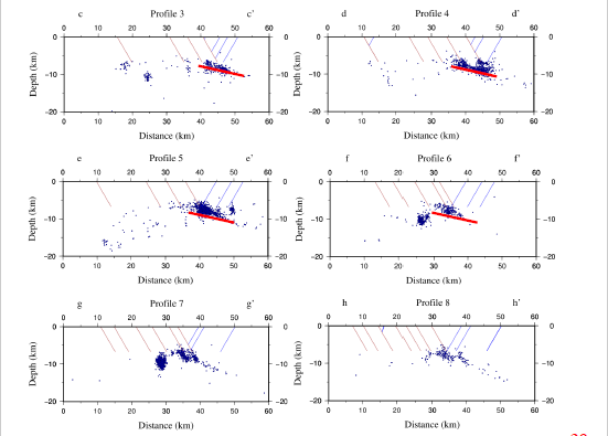
Fig.11 Result showed that, offshore fault keeping very low angle normal faults goes over north-south cross-section. Professor showed to the audience, profile-3 and profile-4 almost similar, profile-5 is not clustered and profile-6 is high angle fault.
He showed that 1000 of small earthquake formed from low angle normal fault in this area and unveiled that the mechanism of the fast expansion on this rift is the low angle normal fault.
Dr. Ganas mentioned that, to find out the deformation of inland, we cannot use INSAR because it has lots of noise. So, he used GPS.
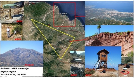
Fig.12ASPIDA-3 GPS campaign Aegion region, red lines are the active fault.
According to Dr. Ganas, he drilled the rock and put GPS point and observed for 8 hours. Then he collected observation data and measured position for the time.
He added, during this job, researchers have to be very careful. Less error brings good data and good data brings precise results. Then he insisted that, people may not like you for some reason, but they cannot disagree with the data.
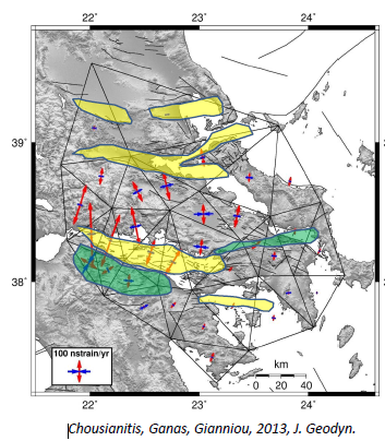
Fig13:(1) Principal axes of strain rates in central Greece from Cardozo and Allmendinger using Delaunay triangulation (2) Strain rate ranges from 10 ns/yr up to 270 ns/yr. Red arrows indicate extensions and dark blue are for compression.
He added, we can map the deformation with GPS over larger scale (e.g. 500 kilometers or 1000 kilometers). Then he described the data collection process, and presented the position of triangle vertices which are GPS stations. Those GPS stations have data for at least 3 years, so he took the vertices and the horizontal components, in east, north and vertical three directions. He said, there is a change of 2 mm over two antennas but the distance of two antennas is 1000 kilometers. This is very small deformation.
Dr. Ganas used the process of axes of strain rates in central Greece and his team collected the last 10 years strain data. The result shows the extension is affecting 800 kilometers of central Greece near the gulf of Geodyn.
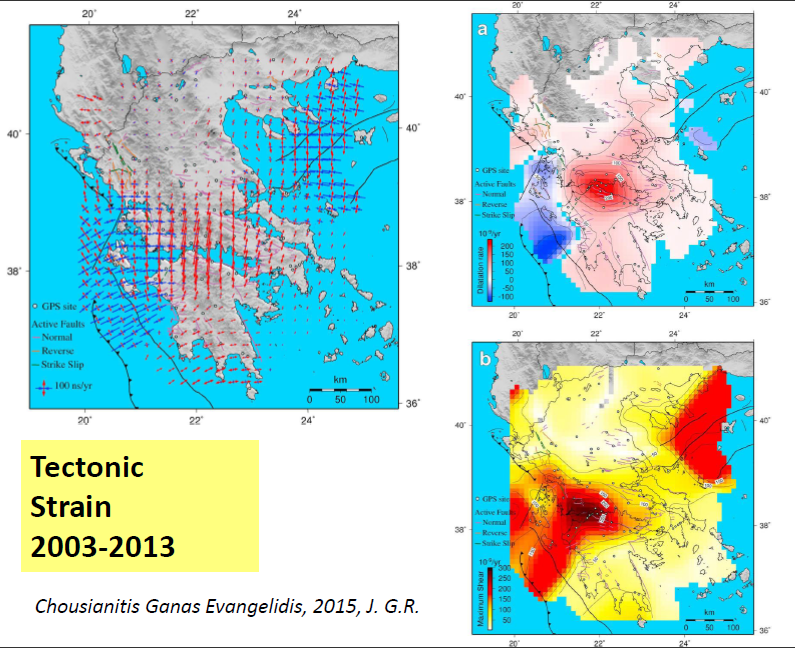
Fig.14Tectonic strain 2003-2013
Dr. Ganas said, deformation happened when shape changed. If the shape doesn`t have any change, it`s not deformation. This change happens due to the result of two processes: translation and rotation.
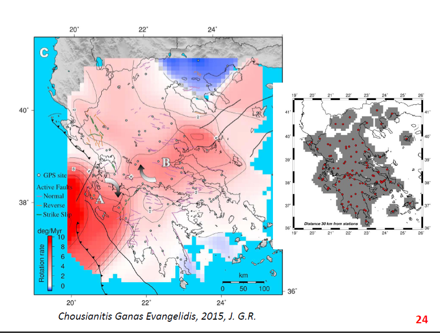
Fig.15area A and area B are in clockwise rotation with rate of 4 degree per million years. All the red dots are permanent GPS stations
According to Dr. Ganas, “If you have fault model then you can explain hazards to estimate hazards from the catalog”.
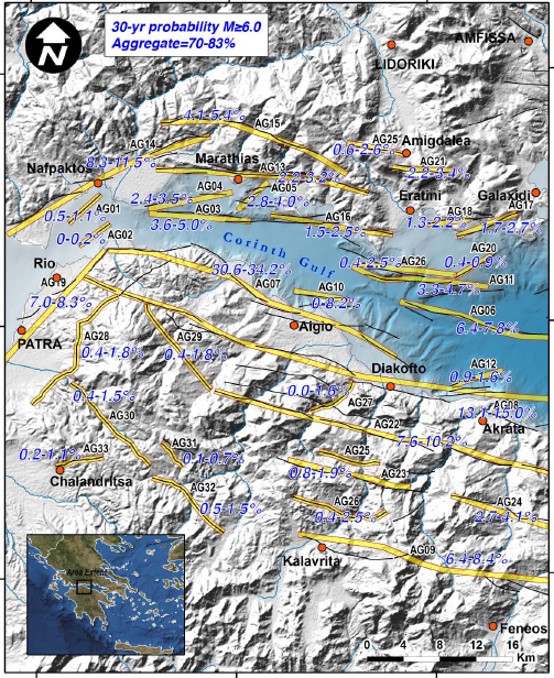
Fig.16All of these yellow lines in maps are active faults and eruptions in last few centuries. These faults are either in north or south. It calculates the probability of earthquake`s magnitude up to 6, which is 70% in the next 30 years.
Finally Dr. Ganas said researchers need to create a fault model and link these faults and calculate the probability, if they want to explain or predict earthquake.
Question and Answer:
Audience1:When you collect data through GPS, does the ionospheric problem affects the result?
Dr. Athanassios Ganas:Yes, this is a common problem for all scientists when using GPS data. There are two ways to process the GPS data. One way is to use double difference method and the second way is to use the precise point positioning. For both methods there are algorithms that consider these constraints. But the longer the data set span, the less will the gaps be. So, we have 10-year data where the shape of data has linear time series of data. So, we are very confident about data and the errors we accept are 10% of the signal or less. So, to sum up your answer, we cannot get rid of ionospheric error but we can compensate it by 10 years of data. When we make the trends of time series, this error is really minimized.
At the end, session-18 ended with a smiling group photo.
